
Wild Hillacious Century Series Routes
Wild Comstock Century
Starting at the Mormon Station State Park in Genoa, this route works it's way via Eagle Ridge and Jacks Valley over to Clear Creek Rd for the ascent up to Hwy 50 and then over Spooner Summit. Ride along the east side of Lake Tahoe and then up and over Mt rose Hwy. The descent carries some traffic, be careful and use pull-outs to let vehicles by. Next, up Geiger Grade to Cartwright Rd. Take the left for the Lousetown Loop back to the highway and into Virginia City. Chose the Truck Route or the short route thru Gold Hill to Hwy 50. hwy 50 to a left on Deer Run Road. Work your way back to hwy 395 and Jacks Valley Road for the return to Genoa. In order to get the miles and feet for the Wild Hill credit, don't pass up the Eagle Ridge, Lousetown Loop, and Deer Run Road sections.
Route Map
Wild Comstock Metric
The Metric Route starts at Fuji Park across from Costco on Clear Creek Rd. Arrange to meet the Century riders here and continue up Clear Creek Rd and Hwy 50 to Spooner Summit. Ride along the east side of Lake Tahoe to Incline Village and up and over Mt. Rose Hwy. Take 395, Franktown and Lakeview thru Washo Valley back to Carson. Use the bike trail and make your to Kings Canyon and back street as much as possible to Fuji Park. Many places along the way for food and drink.Route Map
Wild Hell's Kitchen Century and Metric
One of the most popular club routes, this starts in Markleeville, ascends Ebbetts Pass and Pacific Grade on the way to Alpine Lake and Bear Valley for lunch. Metric riders return from here. Century riders continue west to the Hell's Kitchen overlook and a short backtrack to Spicer Meadow Rd for and 18 mile roller out and back to Spicer Reservoir. Seasonally, there is water at the campground. Return over Pacific Grade and Ebbetts for a total of about 101 miles and 10,400 ft of climbing.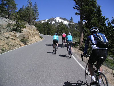
Route Map
Wild Hillacious South Tahoe Century
We start at the bottom of Kingsbury Grade with the South Tahoe Metric riders in Carson Valley for the 2500 ft climb and down to So Tahoe, Pioneer Trail to Hwey 50, South Upper Truckee to Old Luther and to the top of Luther Pass on 89 and return the same way. Century riders having lost all their senses add in Old Meyers Grade to Echo Lake and Emerald Bay Rd oth to Emerald Bay and back and and side trip up to the Sagecoach Lift at Heavenly Valley for more miles and feet. Plenty of places in South Tahoe and Meyers to replenish. About 98 miles and 10400 feet...mostly pretty moderate climbing.Route Map
Wild Hillacious South Tahoe Metric
We start at the bottom of Kingsbury Grade with the South Tahoe Century riders in Carson Valley for the 2500 ft climb and down to So Tahoe, Pioneer Trail to Hwey 50, South Upper Truckee to Old Luther and to the top of Luther Pass on 89 and return the same way. Century riders having lost all their senses add in Old Meyers Grade to Echo Lake, Emerald Bay and Stagecoach Lift of Heavenly for more miles and feet About 63 miles and 7000 feet...mostly pretty moderate climbing.Route Map
Wild Mormon Emigrant Century
Cautionary Note: While there is a printable cue sheet on the map link, this route is very difficult to follow and remote. It should be led by someone who has ridden it enough to be very familiar with it. In addition, this can be a very warm ride and there is seasonal water at only 3 points, 2 of which come very early and late on the route. A SAG is highly recommended. Century riders should start 1 1/2 to 2 hours before Metric riders to meet up at Mormon Emigrant Rd. Despite the warning, this is a beautiful club favorite and worthy of your "to do" list. Starting at Kyburz ascend Silver Fork past water at Silver Fork Camp to its junction with Mormon Emigrant Rd where century riders meet metric riders coming down from their start on Hwy 88. Turn right and descend to a left onto Bonetti Rd. From here all the way to Hwy 88 the route is on small twisty mostly paved forest service roads with many names and numbers. Lunch and water is at Capps Crossing Campground at about mile 52. More twisty forest service roads such as Cat Canyon will bring you to Mehrten Rd for the final climb to Hwy 88. Don't take turns to Grizzly Flat or Pipi. Ride Hwy 88 to a left onto Mormon Emigrant Rd, return to Silver Creek Rd for the descent past water at Silver Fork and onto Kyburz. About 104 miles and 10,800 ft of climbing.
Route Map
Wild Mormon Emigrant Metric Century
Cautionary Note: While there is a printable cue sheet on the map link, this route is very difficult to follow and remote. It should be led by someone who has ridden it enough to be very familiar with it. In addition, this can be a very warm ride and there is seasonal water at only 1 point about the half way. A SAG is highly recommended. Metric riders should start 1 1/2 to 2 hours after century riders to meet up at Mormon Emigrant Rd. Despite the warning, this is a beautiful club favorite and worthy of your "to do" list. Roller coaster along Mormon Emigrant to the junction with silver Fork Rd where metric riders meet century riders coming up from their start at Kyburz. Descend Mormon Emigrant to a left onto Bonetti Rd. From here all the way to Hwy 88 the route is on small twisty mostly paved forest service roads with many names and numbers. Lunch and water is at Capps Crossing Campground at about mile 39. More twisty forest service roads such as Cat Canyon will bring you to Mehrten Spring Rd for the final climb to Hwy 88. Don't take turns to Grizzly Flat or Pipi. Ride Hwy 88 to a left onto Mormon Emigrant Rd. About 63-70 miles and 6500-7000 ft of climbing depending on the exact route.
Route Map
Wild Packsaddle Century and Metric
This is a great route of contrasts. While Hwy 50 and 88 can carry some traffic, the remainder is on narrow, remote and lonely paved forest service roads. Ascend Old Meyers Grade. Be careful crossing Hwy 50 while ascending Old Meyers Grade, it requires that you turn right on Hwy 50 for about 50 yards and then turn left across traffic to get back on Old Meyers Grade. Carefuly descend Hwy 50 with some traffic. There is food and water at the store at Strawberry but there may be nothing else until Silver Lake or Kirkwood. The Silver Lake Campground after Packsaddle Pass may have water if open. Don't miss the left turn off Hwy 50 less than 1/2 mile below the Strawberry Lodge to gain Packsaddle Road. Ride over Packsaddle Pass on tiny paved forest roads and descend to Silver Fork Rd. Turn left and ascend to Mormon Emigrant Rd. Another left and ascend to Hwy 88. Take 88 over The Spur and Carson Pass to Blue Lakes Rd. Century riders do the out and back to Blue Lakes. Seasonally, there is water at Hope Vally Camp and at the Blue Lakes Camp. If you want to avoid the traffic ascending Luther Pass, don't miss the Old Road just behind the rest stop before Hwy 89. After Luther Pass, you can avoid the descending traffic by turning right at Big Meadows and following the pavement all the way down past 89 again to South Upper Truckee road. Take plenty of food and water, a camera and look at the map closely! This is one of the few Wild Hill routes that is best done with a SAG. The Metric Route eliminates the Blue Lakes spur and is about 79 mile and 7900 ft. The century is 100 miles and just 10,000.
Route Map
Wild Spring Century
For 2011, the route starts at Alpine School in Woodfords. Riders will make their way through Diamond Valley and Carson Valley to the 7-11 at Riverview and 395. Ascend Simee Dimeh Summit and on to the start of the east climb up Monitor Pass. Continue to Markleeville and back to the start for lunch. Metric rider are done! Century riders can use Diamond Valley, Carson River Road or Emigrant Trail down to Fotthill then continue to the base of Kingsbury Grade. Ride Kingsbury over Daggett Pass and down to Hwy 50. Use Pioneer Trail to Meyers and either Hwy 89 or So. Upper Truckee to 89, over Luther Pass and back down to Woodfords and the start. About 120 miles/10,500 ft for the century and 68 miles/5,200 ft for the Metric.
Route Map
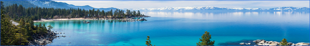
Wild Tahoe Century
Starts at the bottom of Kingsbury Grade, NV 206 and 207. Ascend to Daggett Pass and down to Hwy 50. Hwy 50 through So. Tahoe carries some traffic. Use bike paths if desired. Hwy 89 all the way to Tahoe City and ....again use bike paths as neeed. Continue around the lake on NV 28 to Incline where anther 2500 climb and descent on Mt Rose hwy awaits. Back onto NV 28 along the east side of lake Tahoe to Hwy and back to Kingsbury Grade for the final climb up and back down to the start. About 108 miles and 10,200 ft. Theses roads carry some traffic....be aware of your surroundings. Many places to eat and drink.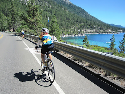
Route Map
Wild Tahoe Metric
The Metric shares the same start as the century ride at the bottom of Kingsbury Grade, NV 206/207. Ride with the Century riders through So. Tahoe to Emerald Bay and turn around at the Vikingsholm overlook parking lot. Return via Fallen Leaf, Tahoe Mountain, Lake Tahoe Blvd and No. Upper Truckee to Hwy 50 in Meyers. Head back to kingsbury Grade via Pioneer Trail and Hwy 50. To get the required miles and feet for Wild Hill credit, turn right on So. Benjamin while ascending Kingsbury and ride to Tramway and the Stagecoach Lift at Heavenly and back to the Daggett Summit and then descend to the start. About 63 miles 6300 feet.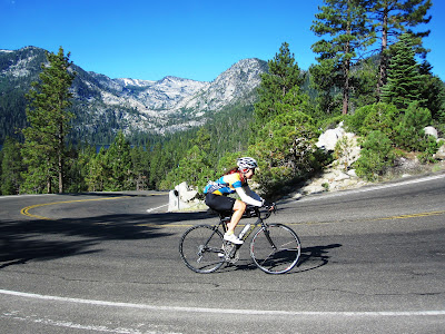
Route Map
Wild Tahoe Rose Century
Start at Galena High School or in the Summit Mall at FatBurger and head up Mt. Rose Hwy. This is a designated bike route but carries plenty of traffic...be aware! Descend to Incline and choose your direction around the Lake. Return over Mt. Rose Hwy to the start finish. If you would like to make a bigger day, add Kingsbury Grade, Baxter Pass, Donner Pass or Brockway Summit for you riding pleasure...woah! About 117 miles and 10,200 ft of climbing without the extras!
Route Map
Willd Donner Century/Metric
Century Route Starts at Galena High School, up over Mt. Rose Summit, over Brockway Summit to Truckee and on to the top of Old Donner Pass where Century riders turn around. Return is via Hwy 89 to Tahoe City, then back to Incline and up and over Mt. Rose Summit for the final insult. There ae plenty of places to refuel and get water. The east side of Mt. Rose Hwy carries some traffic and has little shoulder in places. Be careful nd aware of your surroundings. 103 miles and a little over 10,000 feet of climbing. Metric Route Starts at Galena High School and turns around at the top of Brockway Summit. 61 miles and about 7,200 ft of climbing with the same caution on the east side of Mt. Rose Hwy.
Route Map